Friday, May 28, 2021

Salcombe to Fishguard

After a month in St. Helier Marina on Jersey, we got up bright and early on May Day morning and finished preparing the boat for an overnight sail across the English Channel to Salcombe. We would be "buddy sailing" with another Garcia Exploration 45, "Snow Gum", crewed by an Australian couple, Carolyn and Rick. We crossed the sill at St. Helier just before 9AM and headed out into the Channel, with Snow Gum close behind.

If you look at a chart, it seems as if you could just take a straight line from the western edge of Jersey (off La Corbière) to Salcombe and sail right across. The reality is quite different. There are strong tidal currents to contend with, as well as (obviously) the ever-changing winds (or, often, lack thereof...), rocks to be avoided, and shipping lanes (technically "traffic separation schemes") to be crossed (by law) at right angles. So our path to Salcombe is pretty wonky.


We were both on deck for most of the day, and around sunset I went below for a nap, leaving Katy on watch. We swapped places at midnight, just as we were about to pass the southwestern end of the traffic separation scheme. 

There was a lot of traffic, almost all of it much bigger than Idril - tankers, container ships, ferries, and fishing vessels. Our AIS provides us with excellent information on the ships around us, but we still have to keep a careful watch visually and via RADAR. Some ships (notably military vessels) do not broadcast their locations via AIS, and fishing boats have been known to turn off AIS if they have found a particularly fruitful spot. Nonetheless, AIS is a huge help. We've found that giant ships will happily alter course a degree or so to avoid us - as long as we give them enough advance warning. A typical VHF radio exchange might go something like this:

"Big Ship, Big Ship, Big Ship [using their name, of course], this is sailing vessel Idril, sailing vessel Idril, on channel one six, good evening, over."
"Idril, this is Big Ship. Over."
"Big Ship, Idril. It looks like we will be close to you in about a half hour. What is your intention? Over."
"Idril, Big Ship, we see you on AIS and will alter course 2 degrees to [port/starboard] to pass [in front of/behind] you. Over"
"Big Ship, Idril, thank you very much, have a pleasant watch. Idril out."


I got Katy up around daybreak (early at this latitude...) and we shared the cockpit for the rest of the trip, with me dozing a bit. We arrived at the entrance to the Salcombe estuary around 9AM, and were tied up on the visitor pontoon by 11. Snow Gum arrived shortly thereafter.

The next 3 days were filled with very satisfying walks around the Salcombe coastline: to the north, the south, and inland to the sheep meadows above the visitor pontoon.


We also had fun walking around town.


 On Thursday, May 6th we left Salcombe at first light (5:30am) and sailed to Mylor Yacht Harbor in Falmouth -- a place we know very well from the month we spent there last summer, having our electrical system tweaked. This gave us a chance to do laundry, re-provision and finally get our bikes shipped off to Gocycle for service. Once we had a decent weather window, we took a short hop on Tuesday, May 11th from Mylor to a mooring in the Helford River -- also familiar from last summer -- before taking off two days later, on the 13th, for the Isles of Scilly.

We had some excitement on the way to the Scillys -- our gennaker halyard failed. The halyard is the line that we use to hoist the top end of the gennaker, our primary light-air sail, to the top of the mast. The line has two parts -- a very strong inner core, and an abrasion-resistant outer braided sheath. The sheath failed, apparently at the point where it was gripped by the clutch on the mast, and the inner core slipped down inside the sheath.  This allowed the top of the sail to drop about 3 meters or so, bringing the bottom edge of the sail dangerously close to the water. We were zipping along at a good clip past Lizard Point, the southernmost spot in "mainland" England, with somewhat rough seas. Had the sail really dug in to the water, we would have damaged at least the sail.

Luckily, Katy reacted immediately, unfurling the solent (another of our foresails), stealing the wind from the gennaker and easing the pressure on the line. We were then able to safely lower the gennaker and lash it to the lifelines on the port side of the boat. In the rough seas and stress, I (Jerry) got increasingly nauseous, and eventually blew my breakfast all over the port side deck. Yech.

 We later discovered that a photographer on Lizard Point had captured the boat  moments after the failure, just as we had gotten the solent unfurled.

The beginning of the recovery operation

The gennaker lashed to the port lifeline

 We arrived at The Cove, a quiet (and familiar) anchorage off St. Agnes in the Isles of Scilly in the late afternoon. We got the gennaker properly stowed, cleaned up the side deck, and turned in early. 


Arriving at The Cove

The next morning we got up early and went for a walk on St. Agnes, including a stop at Troytown Farm for a breakfast of ice cream, and a visit from a very insistent bird.

Then -- back to the boat, and a shift to New Grimsby Harbour, between the islands of Tresco and Bryher. 

Passing "the cow", north of St. Agnes

We were waiting for good winds for the next leg, to Milford Haven in Wales. We spent the days walking mostly-familiar coastal paths on Bryher, re-visiting Tresco Abbey Garden, and resting up for the 118 nautical miles to Milford Haven.

We left New Grimsby in the late afternoon on May 19th, in stronger-than-expected winds and chop. Katy took the first night watch at 11pm, while I snoozed until 3am and we swapped roles. Around 5:30, shortly after sunrise, I realized that the boat was surrounded by dolphins. Magical! Click for video.


The wind was unfortunately fading as the sun rose, and we wound up motoring much of the rest of the way to Milford Haven, arriving midday.


A friend has called Milford Haven "the Detroit of Wales"; it is a pretty industrial port, with a major LNG terminal and plenty of commercial shipping traffic. But we did get in one nice walk.


But once we got another weather window, we were eager to press on, and on May 22nd we left Milford Haven at the 9am lock opening and headed for Fishguard, through the first two of a series of somewhat tricky passages -- Jack Sound and Ramsey Sound.

The blue line is our track

As we move north into the Irish Sea we will increasingly encounter very strong tidal currents, as water is shoved north and south between Ireland and Wales. Katy is now putting significant time and energy into making sure that we arrive at key choke points near slack tide and with favorable winds. Jerry, on the other hand, is a slacker.

Hard at work in the cockpit

 We anchored in Fishguard for 2 nights, with one brief trip into the town. It was a lovely place to be anchored, well protected and surrounded by modest cliffs.


Most signage is now in Welsh, with English second

We left Fishguard just before sunrise on Monday, May 24th, and sailed to a Marina in Pwllheli, our next staging point. I'll write about that, and our further progress to Porth Dinllaen and Caernarfon, in another post.

Sunday, May 16, 2021

On the move again - but first, a recap of Jersey


 Idril is once again on the move. I'll try to catch up on where we've been, but it will take several posts, rather than one big one. I'll start with Jersey.

As noted earlier, we left Cherbourg midday on April 2nd - the day our already-extended-once residence permits expired. We timed our departure for a fair current through the Alderney Race and arrived at St. Helier, on the channel island of Jersey, shortly before dusk.

The sill at the entrance to St. Helier Marina
 
After 11 days of on-boat quarantine in Jersey our "Day 10" COVID-19 test results came back negative, and we were free to leave the boat. Relief!


While in quarantine we were visited (at a distance, of course..) by David and Angie Jeffs, fellow members of the Ocean Cruising Club, who noticed our OCC flying fish burgee on our port spreader. Their apartment overlooks the St. Helier marina, so they have a great view of all the comings and goings of the port. Once we were declared COVID-free they served as our personal guides and trip advisors to Jersey. They took us around the island in their car (along with their cat, Dimanche, who walks on a leash). Some of the sights:

Noirmont Point

La Corbière

Faldouet Dolmen

Dimanche at our lunch stop

David and Angie also served as local pilots for a day trip in Idril around the entire island. The tides in Jersey are such that you can leave the St. Helier marina and turn east, sailing counter-clockwise around the island with a fair current for almost the entire trip. We had light winds and sunny skies, and got to see the whole coastline from the water.

Our route around Jersey


Aboard Idril

Angie and David have two boats of their own -- a 60 foot barge on which they cruise the rivers and canals of Europe, and a 28 foot Westerly "bilge keel" boat named Breton Girl for sailing around Jersey and coastal France. They took us for a lovely day sail aboard Breton Girl.

Prepping Breton Girl for sea

While in Jersey we also got our first doses of the AstraZeneca vaccine. Yea!


We did a lot of walking, especially along the rugged northern coast. There is excellent bus service throughout the island, so we could take a bus to the start of a walk and back from the end.


We also did a bunch of bike riding, sometimes as a way to get to walks that were not so easily reached by bus. Some of the sights were quite whimsical.


On May Day morning we said farewell to Jersey and sailed overnight across the English Channel to Salcombe. But that's a story for another post.

For more pictures, visit:


Wednesday, April 28, 2021

St. Helier Tides

 Jersey has a roughly 12 meter tidal range (the difference in "sea level" between the lowest and highest stages of tidal ebb and flood). It's hard to comprehend just what that means, but these pictures may help.

The difference in height between high and low water varies according to the monthly lunar cycle, with the largest difference occurring just after new and full moons (so-called "spring tides"), and the smallest difference occurring around the waxing and waning half-moons ("neap tides"). There are other factors that affect the tidal range, so there is also slight variation among spring tide ranges from month to month.

 We are, as I write this, at the height of this month's spring tide, with the port of St. Helier having an 11.2 meter difference between high and low water. Here in the marina, we are sheltered from the very lowest tide by a "sill", which traps water in the marina as the tide recedes, helping keep the boats behind the sill afloat. So the pictures below don't even reflect the entire tidal range.

This first pair of pictures was taken looking towards Idril, currently docked at the end of the "B" pontoon in St. Helier Marina. Note the large dark piling on the left (with a white cap labeled "B" on its top).

Low water

High water. Yes, Katy has her foot on the top of that same piling.

This next pair shows the "Welcome" sign on the marina seawall at low and high water.


If you look closely at the bottom of that railing, it becomes clear that even a slight storm surge would flood that sidewalk and street at the top of the seawall, to say nothing of what a meter of sea level rise would do.

There is a ramp from the pontoons up to the top of the seawall and the marina office and facilities. The angle of that ramp varies a lot, too. At high water springs, the ramp actually slopes slightly down from the pontoons to the gate.


Finally, remember that sill I mentioned, which we have to sail over to get into the marina? Here's the view from the outside of the marina at low water springs. The water in the marina is protected from going that low by the sill.


There are a few more pictures of the tidal range, including some "high water humor", in this album.


Saturday, April 10, 2021

St. Vincent volcano from space

 Yesterday (Friday, April 9, 2021) the La Soufrière volcano on St. Vincent in the Caribbean erupted explosively.  I went looking for good images on news sites, with little success, so I went to the NOAA satellite imagery site and poked around.

Sure enough - there are images from GOES (the Geostationary Operational Environmental Satellite system). I used their image capture tool to download successive images at 10 minute intervals. You can find them all in this album.


Monday, April 5, 2021

Cherbourg to Jersey

 Katy and I are now in St. Helier Marina on the Channel Island of Jersey. We left Cherbourg a bit after noon on Good Friday and arrived shortly before dusk. We positively flew for most of the trip. We had strong (25-35 knot) east-northeast winds most of the way, we were able to catch a helpful west-going tidal eddy as we passed along the northwest corner of the Cotentin peninsula, and we had tidal currents with us for the remainder of the voyage. Here's our track from Marine Traffic:


We averaged 9.9 knots!

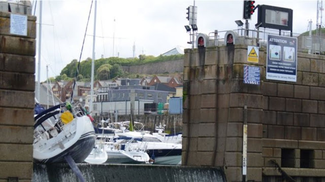
We're settled onto the "hammerhead" end of "B" dock, which gives us a good view of the entrance to the marina. We get to watch a steady stream of boat traffic for entertainment while the marina is open, which is three hours each side of high tide. The entrance to the marina is a "sill", which is just what it sounds like: a wall, or set of low gates, that retain the water in the marina at a sufficient height. That height is low relative to the entire tidal range (which, here in Jersey, is an enormous 12 meters!), so during the period around high tide, boats can float in and out over the sill. In an area with large tide swings, it's an elegant solution to keeping boats afloat during low tide without the need for locks or swinging gates. But you must time your arrival and departure such that your boat (including its keel and rudder...) will clear the sill. Here's what happens if you don't:


Ouch... 


We'll be here for at least two weeks, with the first 11 days spent strictly aboard the boat in quarantine. We had our "day zero" COVID-19 arrival tests (negative - yea!) on Saturday morning, which will be followed by 5- and 10-day tests. Assuming those next two tests are also negative, we'll be released on day 11, and can begin exploring Jersey. And, assuming the rules don't change (a large assumption...), we'll then be able to sail directly from Jersey to the southern coast of the U.K. and not have to quarantine upon arrival. We should also be able to get the first of two vaccination shots before we leave, getting us started on the road towards a little less worry about the coronavirus.

How did we wind up in Jersey? There's a bit of a tale to tell.

Our goal for some time had been to leave Cherbourg by the end of last week (Friday, April 2nd). While we have informal assurance from the Manche prefecture that our residence permits will be renewed for another 3 months, we have nothing official to that effect, so we figured that we had best be gone by midnight on April 2nd to avoid overstaying our current permits.

Our initial plan was to go to Portsmouth or Southampton on the southern coast of England. We would have to quarantine for 10 days after arrival, but we figured we could probably manage to get our GoCycles sent off for some required service during that time, which would be great: we can't ride them while in quarantine. We had a berth reserved in Portsmouth and were settled on that plan, when we discovered, somewhat by accident, that we would not be able to quarantine on the boat, but would have to go to a special quarantine hotel - at 750 GBP per night!

Ouch.

A few frantic phone calls later, we were assured by the harbor master in St. Helier that we could quarantine on the boat, so Jersey it was.

Checking out of Cherbourg was interesting. Before Brexit, there was little point in "officially" clearing out of Cherbourg, since nearly all destinations in easy reach were in the Schengen free-travel zone. Now, though, since we were headed to Jersey, we really needed to formally leave France. But there isn't any obvious place to do that in Cherbourg.

So - we scheduled a visit by the "PAF" (the French border police) for early Friday morning. Two very pleasant and polite officers arrived at the boat at 5:30AM, stamped our passports, and were on their way. We're committed!

As noted above, we left about 12:30PM and had a great sail over.

On Saturday morning, after our day zero tests, we were visited by the Jersey customs officers and had our passports stamped for entry to Jersey. We should be good for 6 months in the Common Travel Area without further visa issues. Yea!

Pictures from the trip here.


Sunday, March 14, 2021

Conservatives?

 Those of you following this blog to read reports of Jerry and Katy sailing aboard Idril can close this tab right now. This has nothing to do with sailing.

I follow (and support on Patreon) a podcast called "Know Your Enemy" by Matthew Sitman and Sam Adler-Bell that (generally) discusses the history, methods and goals of the Conservative movement in America. (I wonder if they would agree with that assessment?)

 The "logo" of the podcast is an iconic (at least to me, a certified Old Farte...) image of William F. Buckley, host of Firing Line and founder of the National Review.


 In the comments section of Patreon, someone recently posed this question:

Who is the dude featured in KYE's thumbnail?

 I was greatly amused, and then more thoughtfully realized that Mr. Buckley is probably completely unknown to the vast majority of current Americans.

So - who might be a conservative whose image would be recognizable to people under 40, and who might be appropriate in the context of Know Your Enemy, which is about much more than just the current batch of Trumpian morons in control of the Republican party?

In that spirit, here are some images for your consideration. Most of them are similar Old Dead White Guys, but a few are of a more recent vintage. Can you name them? Note: One is an Easter Egg, not a Conservative.

Enjoy!


Hint: "In your heart - you KNOW he's right."